The first challenge in managing abandoned oil and gas sites is finding the wells "lost to time." Across the US, hundreds of thousands of forgotten and undocumented orphaned wells (UOWs)—many drilled before GPS or digital records—lack known operators and often have little to no surface equipment, making them difficult to locate.
While "orphan wells" (abandoned wells with no owner that have become wards of the state) and "marginal wells" (low-producing wells nearing the end of their lives) present distinct legal and technical challenges, AI is being used to locate, prioritize, and plug them more efficiently. The first problem faced is finding the wells “lost to time”.

Ok, maybe they aren’t really lost in time or invisible, but they may have little to no surface equipment, making them difficult to locate. The biggest hurdle with orphan wells is that many were drilled or dug long ago—before GPS or digital records existed. What can be scary is the unknown unknowns; Across the US lie the scattered remnants of nearly 170 years of commercial drilling, resulting in hundreds of thousands of forgotten oil and gas wells.
These undocumented orphaned wells (UOWs), many of which predate regulatory entities or modern regulatory requirements, are not recorded in official listings and lack a known (or financially solvent) operator. They often present a hazardous combination, as they are both out of sight and out of mind.
There are an estimated "300,000 to 800,000" undocumented wells in the US alone. Using a single tool or approach to the exclusion of others will not make a significant dent in the problem because of the different types of records each tool uses to infer locations, so we are outlining below some of the novel and dynamic approaches that are being developed to tackle it.
"Digital Archaeology" AI-Enhanced Archival Scans: It's now possible to use AI, Enhanced Computer Vision, to scan thousands of hand-drawn maps and ledger books from the late 1800s and early 1900s. AI can cross-reference old landmarks (e.g., "50 paces from Miller’s Barn") against modern topographic maps.
Historical Aerial Overlays
Many government agencies have aerial photos dating back to the 1930s. By overlaying these onto modern Google Earth data, you can see where access roads or clearings once existed, where wells are more likely to be found. This is a painstaking process that humans are just not good at doing at scale. AI, with a well-trained model coupled with Agentic Workflows, can easily handle this very tedious work on a very meaningful scale, allowing us to find these wells lost in time so they can be eventually plugged.
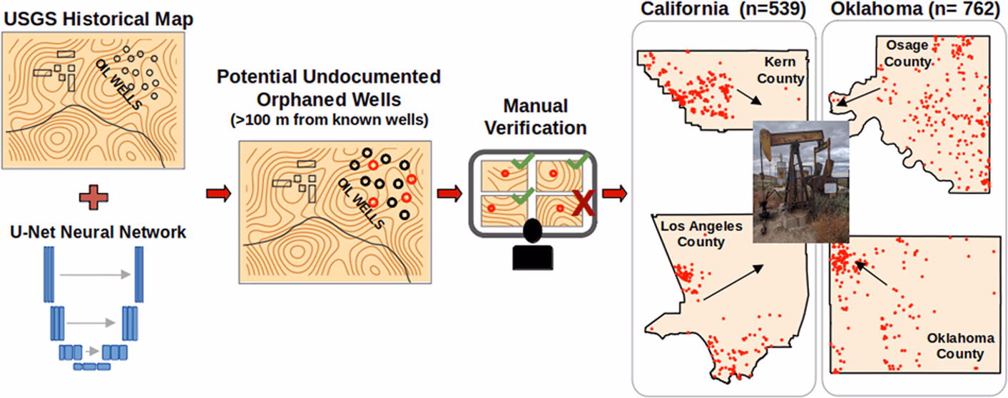
Undocumented orphaned wells are identified in four counties in California and Oklahoma from historical topographic maps using a computer vision neural network (credit: Environ. Sci. Technol. 2024, 58, 50, 22194-22203)
The challenge is further compounded by a number of factors related to the age of these wells, evolving state regulations, and changes in technology and recordkeeping over time:
- Old wells that were improperly plugged under earlier standards or prior regulatory oversight
- Orphaned and long-term idle wells with unclear ownership or responsibility
- Wells that have been partially or fully cannibalized, with surface and subsurface equipment removed or relocated over time
- Wells constructed with outdated materials (e.g., wooden casing) that are difficult to detect and assess
- Changes in land grids, survey methods, and property ownership that obscure original well locations
- Incomplete, inconsistent, or falsified historical records
- Wells were drilled prior to the establishment of formal regulatory agencies, resulting in little to no official documentation
Many others are working on this problem alongside us
One of our favorites is Historical Map Digitization. Researchers at Lawrence Berkeley National Laboratory are using "Vision-Language Models" (like U-Net) to scan thousands of historical topographic maps from the nineteenth and twentieth centuries. The AI learns to identify tiny hand-drawn symbols for wellheads and cross-references them against modern databases to find "missing" sites.
Community-Led Crowdsourcing: Since a huge number of these are on private land, the people who live there are often the best resource.
- Using the WellFinder app to research whether the well is documented or not.
- "Orphan Wells Location Survey" (OWL) The Department of Energy (DOE) and the National Energy Technology Laboratory (NETL) have actually launched citizen science initiatives. They encourage people to help identify wells because, as you noted, there are hundreds of thousands of "lost" ones. They often use these volunteer-submitted coordinates to send out the drone-based magnetometers I mentioned earlier.
- We love the Well Done Foundation (WDF) - is one of the most active non-profits in this space. They don’t just wait for the government; they actively recruit the public.
- This is so cool - how can we get this program to scale across the US? Senior Citizen "Well Hunters" (The Kolojejchick Group) In Western Pennsylvania, a group of retirees (led by volunteers like senior citizen John Kolojejchick) became legendary in the industry.
- The Method: This group of seniors spent years hiking through state parks and forests using old, 100-year-old paper maps.
- The Result: They have personally located nearly 1,000 undocumented wells that were missing from official state records. They essentially did the "archaeological" work that state agencies didn't have the staff to do, proving that local knowledge and persistence can outperform high-tech sensors.
Technology Solutions
Sensor Fusion & Drones
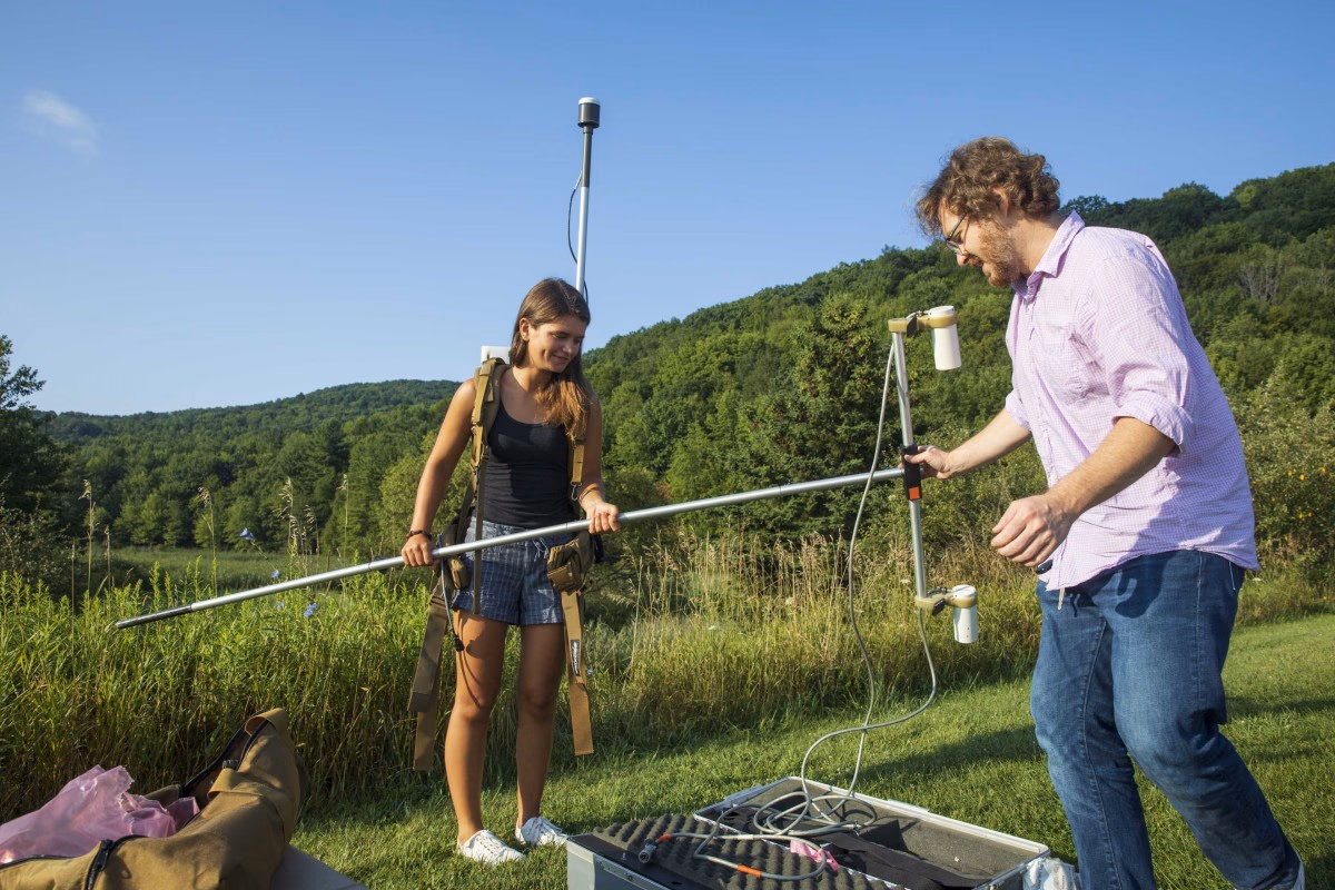
Human held equipment is still being used but drones are becoming more common as a practical alternative for remote sensing (credit: From the air: Drone technology locates unplugged oil and gas wells)
AI (Convolutional Neural Networks (CNNs) and Recurrent Neural Networks (RNNs)) is used to process "noisy" data from drones equipped with magnetometers, which detect metal well casings underground, and LiDAR, which can "see" through thick forest canopies to find the physical depressions left by old well pads. These depressions can indicate wells from which equipment had previously been removed, wells with wooden casing, and wells that were stripped during WWII).
Methane Sniffing
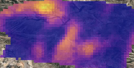
MethaneSAT produces high precision, high resolution quantitative data (credit: Novel observations reveal methane emissions from oil and gas operations that other satellites don’t see)
Satellites like *MethaneSAT* use AI ("Color Fingerprint" (Spectral Analysis)) to analyze spectral data, pinpointing methane plumes back to specific coordinates where no active well is currently recorded.
Satellite-based Measurement Systems
Given the volume of satellite data available, we should utilize AI (Computer Vision (The "Satellite Eyes")) analysis. Human review alone cannot cover the sheer amount of information. Although current satellite systems primarily detect only large methane releases, this illustrates the potential for technology to expand its capabilities in monitoring methane emissions.
Leverage Data Science and Digital Twins
AI is instrumental in creating digital replicas, or "digital twins," of aging wells. BIG IF we have located the well and can monitor the well we can try to do risk analysis on the well. By continuously analyzing real-time data such as pressure, temperature, and flow rates, this AI can proactively predict and flag potential issues, like casing failures or the start of a leak, before they escalate into major environmental hazards or necessitate costly emergency shutdowns. This predictive capability significantly enhances operational safety and minimizes environmental impact.
What we (Troy Web Consulting) have done
In a recent project,

This blog was co-authored in collaboration with the experts at All Consulting (ALL)
ALL is a specialized professional engineering, environmental, and technical services firm focusing on leading-edge challenges that face the Oil & Gas upstream and midstream marketplaces. ALL experienced management team and staff bring countless years of combined and distinct experience to this marketplace. Their diversity and depth of experience have uniquely positioned them to have all service and delivery aspects designed, engineered, permitted, managed, and delivered within one cohesive organization. This broad service and delivery capability allows ALL to provide a more efficient and comprehensive project delivery process to their clients.
Share this article